
 Login
Login
 |
Athens Park(Park near Lake Lanier) |
|
Alternate Name(s): Bench Point at Athens Park
Website: adoptashoreline.com/
Addressof Rt 369 , GA 30041 Phone7272043932
Elevation333 meters
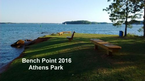
DescriptionAthens Park is an environmental area. It is strictly walk, bike or hike beyond the gate. There is no auto access beyond the gate. If you decide to visit please park on the side - not near the gate. The gate access must be assable for AAS ( adoptashoreline.com) and emergency vehicles. There are several trails but the shortest route ( 4 minute walk) to Bench Point is to follow the road directly behind the gate straight out to the point. Bench Point is one of the most beautiful views on Lake Lanier.
RULES ..... Open from 6am to 9pm, no camping or fires are aloud, no hunting and no firearms of any kind. Understand that Athens Park and surrounding areas are adopted by AAS an environmental community group that states " ENJOY YOUR STAY BUT, please, DON'T LEAVE ANYTHING EXCEPT YOUR FOOTPRINTS. Visit our website at adoptashoreline.com for more info about AAS and AAS's adopted areas. AAS is dedicated to the continual cleanup of Lake Lanier. HISTORY Athens Park has much history! First we have a 200 year old oak tree at Bench Point. On your walk out ,on your left, you will see a stone staircase that leads to several other stone staircases that were , to the best of our research, originally built between 1830s to the 1870s to access the cotton terraces that still exists. These stone staircases were rebuilt in August of 2016 using some of the original stones from the 1800's. The railings were added for your safety. The flat areas that you will be walking on between the staircases, if you choose to walk the staircase, are the terraces that the cotton was planted on. Strictly by coincidence this staircase now leads you down to Athens Cove Beach. Also, when you're standing out on Bench Point and look to your left (east) the next point ( called Lookout Point) is where people used to board the ferry to cross the Chattahoochee River before buford dam was built creating Lake Lanier. ID: DE964878-D08E-498F-A6DC-FF2D518542CF DE964878-D08E-498F-A6DC-FF2D518542CF
|
|
Quick Links Lake Lanier News Lake Lanier Photos Lake Lanier Videos |


